If you are looking for a one-day hike set in the most exotic location, look no farther than the Tongariro Crossing trail on New Zealand’s North Island. Here you will traverse contracts in landscape from dense woodlands to that resembling a Scottish moor and even trek across a volcanic landscape that leaves you feeling as though you have Earth altogether. This trail is not for the faint of heart, however. It includes several steep ascents.
The trail is situated in Tongariro National Park and is widely accepted as the country’s best one-day hike. The park is New Zealand’s first national park and doubles as a world heritage site. Within its borders are three volcanoes: Ruapahu, Tongariro, and Ngauruhoe. The track leads through the Mangatepopo Valley. Following it for about 1.5 km (1mile) brings you to a side trail that leads to the Mangatepopo Hut. Pressing ahead and following a stream, you pass through old lava beds and can enjoy the sight of Mt Ngauruhoe on your left. Roughly 2.5 km (1.5 miles) farther along the track you will reach the valley head from which you can reach a cold water spring, Soda Springs, by taking a short detour. The springs are surrounded by lush plant life.
Continuing on, the hike gets serious as you start ascending the saddle that lies between Mt Ngauruhoe and Mt Tongariro. Form here you are rewarded with amazing views of Tongariro and a clear day, of Mt Taranaki due west. From the saddle, the truly adventurous can choose to ascend Ngauruhoe, a tough climb over loose rock that can be particularly treacherous when ice is present. This part of the climb takes about three hours.
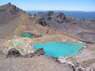
Following the signs from the saddle, trekkers can cross the South Crater. Another 7 km (4.4miles) father down the track, you reach the highest point of the trail, Red Crater. You will be able to tell this volcano is still active by the pungent smell of sulphur in the air. Below, you can see two small water-filled craters named Emerald Lakes because of their high mineral content. High winds and exposure to biting cold make it difficult to stay for very long.
Leaving Emerald Lakes, you will head north and arrive at Central Crater before embarking on a short hike to Blue Lake. Originally called Te Wai-whakaata-o-teRangihiroa (Rangihiroa's Mirror), Blue Lake is an old vent and it was a descendant of Rangihiroa's who donated the main section of Tongariro National Park in 1887.
Almost done now, the trail continues north as you edge North Crater on your descent to Ketetahi Hut. The vista open up and plumes of smoke and mineralstreaked rock formations are visible, part of, Ketetahi Hot Springs. The springs are on privately owned land and not accessible. Be aware that you are now crossing private land and there is no right of access to the springs.
If hiking the Tongariro Crossing appeals to you, contact backpackerdeals.co for assistance planning your trip.


